
Key Highlights
-
The National Weather Service (NWS) gives people reliable weather information across the United States.
-
Knowing the national weather forecast helps you get ready for things like severe thunderstorms and excessive rainfall.
-
The Weather Prediction Center has maps and forecasts for different times in the day.
-
The US gets many types of weather, like heat in the West and storms in the South.
-
Interactive maps and short-range forecasts help you see changes in weather every day.
-
Keeping up with the forecast is important for planning your day and staying safe.
Introduction
Welcome! Do you ever think about what makes the weather change in the United States? The weather can go from clear skies to a big storm in no time. The good news is, you can use some strong tools to know what is coming. The National Weather Service and the Weather Prediction Center give a forecast, so you can get ready for any weather. This guide shows you how to understand US weather. It will help you learn about national patterns, and what tools you can use to get the most up-to-date forecast for where you live.
Understanding National Weather Patterns in the United States
The United States is a big country with many kinds of weather. You might see snow in the mountains on one day, but at the same time, another place could get caught in a heatwave. The National Weather Service is the main source people trust for the weather forecast. Millions get important updates from them, and these updates help us all know what is coming.
When you know how these weather patterns work, you can get ready for things like excessive rainfall or severe thunderstorms. It matters that you know where to get this weather forecast and other details about bad weather. We will take a look at the different systems that affect weather and what sets each climate across the country apart.
Key Weather Systems That Shape US Conditions
The weather you get each day depends on big weather systems that move across the country. High-pressure and low-pressure systems, plus fronts and troughs, help decide if your day will be sunny or if there will be thunderstorms. People at the National Oceanic and Atmospheric Administration (NOAA) keep a close eye on these weather patterns.
For example, a low-pressure system can bring a lot of rain and even severe thunderstorms to the South. At the same time, a high-pressure system over the West can make the sky clear and bring record heat. The way these systems meet is what gives us the national weather forecast. If you want to check the weather forecast for the US this week, you can look at maps and updates from official sources that track these weather changes.
Some weather systems do much more. There can be excessive rainfall that leads to flooding, or strong conditions that may let tornadoes happen. Watching how these weather systems change and move across the country is so important for a good forecast and for keeping people safe.
Regional Climate Variations Across the Country
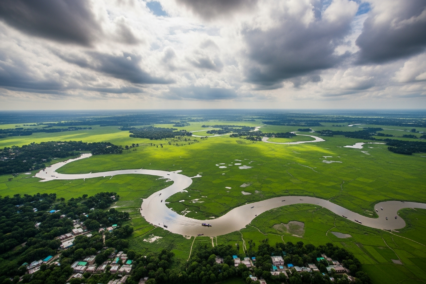
The United States isn’t just large; it’s a patchwork of different climates. The weather forecast for the rainy Pacific Northwest will look very different from the dry, hot Southwest. The Midwest experiences a full range of seasons, while the Southeast is known for its humidity and frequent precipitation.
These regional differences are why a single national weather forecast can’t tell the whole story. You can compare today’s weather conditions in different US cities using tools from sources like the NWS and NOAA. There is no endorsement of any specific private service, but these government agencies provide the raw data many platforms use.
Here’s a simple comparison of typical regional weather:
|
Region |
Typical Weather Characteristics |
|---|---|
|
West |
Often dry with record heat possible, especially inland. |
|
South |
Prone to rain, humidity, and severe storms. |
|
Midwest |
Experiences a mix of conditions, from rain to clear skies. |
|
Northeast |
Can see scattered showers and variable temperatures. |
Exploring US Weather Maps and Forecast Tools
Now that you know about the different kinds of weather, how can you keep track of them? Reliable national weather maps for the United States are easy to find. You can get them from sources like the National Weather Service. These maps give you a simple forecast. They show things like temperature, precipitation, and where severe thunderstorms could happen.
The Weather Prediction Center is focused on these graphic forecasts. It helps you see if there will be severe thunderstorms and lets you know how much rain can fall. If you learn how to use these weather tools, you can become your own weather expert. Next, we will look at interactive maps and where you can get long-term forecasts.
Interactive Weather Maps and Their Uses
Interactive weather maps help you see weather as it happens. These maps do not just give a still image. You get to watch storms build, follow rain as it moves, and check how temperatures change across the country. The National Oceanic and Atmospheric Administration (NOAA) and its Weather Prediction Center give people all of these great tools.
With these maps, you can zoom in on your own spot or look at all of the country. You can put a few types of data on one map, so you get the full picture for the forecast.
Some features you can see on interactive maps are:
-
Radar: Lets you see rain or snow right now, and tells you how strong it is.
-
Temperature: Shows temperatures with colors on different areas.
-
Wind Speed and Direction: Shows how fast wind is blowing and which way it goes.
weather prediction center, national oceanic, atmospheric administration, forecast, noaa, precipitation.
Finding Reliable 7-Day and Short-Range Forecasts
Are you planning your week? You need a good 7-day forecast, and the National Weather Service is the top place to get this. The NWS website has many detailed forecasts for the whole United States. You can look these up by city, state, or zip code. Many news websites and weather apps use data from the NWS and its parent group, NOAA.
The national weather service forecast gives you what to expect each day. If you want to know what is coming soon, short-range forecasts will help. These cover the next 12 to 48 hours. You get more detail about the weather, like pressure and fronts, and how much rain or precipitation you might get.
You can find all this on the NWS website:
-
Medium Range Forecasts: These cover days 3 to 7.
-
Short Range Forecasts: These show the weather for the next 48 hours.
-
Quantitative Precipitation Forecasts: These show how much rain or precipitation you can expect.
Conclusion
In short, knowing the weather in the United States helps you plan your days and keeps you safe. When you spot the main weather trends and see how the climate changes by region, you can use easy forecasting tools to stay up-to-date. Check your local forecast or look at interactive maps. It is smart to have knowledge, so you can deal with the different weather in this country. Be ready for any surprise from Mother Nature. For weather updates that fit where you live, you can sign up for our free alerts.
Frequently Asked Questions
Where can I find up-to-date weather alerts and warnings for the United States?
The best place to get the latest weather alerts and warnings is the National Weather Service (NWS). You can find this at weather.gov. This is the official site of NOAA. The site gives you real-time updates straight from the people who forecast the weather. Another good idea is to turn on Wireless Emergency Alerts (WEA) on your phone. This way, you get a notice right away if there is bad weather.
Keywords: national weather service, nws, noaa
Which websites offer live weather radar and breaking news for US regions?
The National Weather Service (NWS) website has live weather radar for every region in the US. It shows where there is precipitation and when there are severe thunderstorms. The Weather Prediction Center gives detailed maps and more about what is going on.
If you want to know the latest weather forecast or weather news, you can also check your local TV station websites. Trusted national news outlets often give updates about the weather forecast and what to expect.
How can I compare weather conditions across different US cities?
You can compare the weather with other places by going to the National Weather Service (NWS) or NOAA websites. On these sites, you will find a national forecast map. This map lets you see things like temperature, precipitation, and more for many cities at the same time. There are a lot of other weather apps out there, but using these official sites means you get the facts with no commercial endorsement.